PODZVIČÍNSKO
Road accessibility
Information centres
Towns and municipalities
Notable personality
Natural points of interest
Destinační management
Nature and its protection
Natural points of interest
Caves and abysses
Vrcholy, hřebeny, sedla
Fauna a flora
Nature trails
Culture, entertainment, sport
Culture and entertainment
Sport and relaxation
Zimní sporty
Katalog KUDY Z NUDY
Active holiday
Sights and Attractions
Sights and architecture
Ecclesiastical monuments
Castles and chateaux
Tourism and leisure time
Rural tourism
Hiking
Cycling tourism
Water tourism and sports
Wine tourism
Balneology
Spas
Lázeňské domy a sanatoria
Medical cures
Natural medical sources
Congress Tourism
Exhibitions and exhibition grounds
Congress centres
Exhibitions and promotion
Accommodation & dining
Car-camping, camping site
Hotels, Boarding houses
Chaty a chalupy
Recreation areas
Further accommodation
Restaurants
Příjemné posezení
Gastronomic specialities
Po červené: Zvičina - Kuks - Jaroměř (0426)
[ Tourist path KČT ]
CONTACT ADDRESS:
Městské informační centrum
Jana Mikysková
nám. T. G. Masaryka 2
544 17 Dvůr Králové nad Labem
Czechia (CZ)
tel:
(+420) 499 321 742
fax:
(+420) 499 321 742
http://www.mudk.cz
e-mail:
info@mudk.cz
NEXT LINKS
[ Encyclopedic headword ]
Turistické trasy KČT
ev.č.4260
IN DETAIL
0.00 km
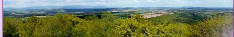
Zvičina
[ Street or locality ]
[
gps
]
, 671.00 m.n.m.
1.00 km
Masarykova studánka
[ Statue, sculptural group or sculpture ]
[
gps
]
, 610.00 m.n.m.
2.00 km
Lázně pod Zvičinou
[ Street or locality ]
[
gps
]
4.00 km
Bílá Třemešná
[ Village or Town/City ]
[
osm
]
4.00 km
Bílá Třemešná
[ Railway ]
[
gps
]
, 380.00 m.n.m.
12.00 km
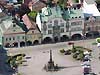
Dvůr Králové nad Labem
[ Village or Town/City ]
[
gps
]
[
osm
]
15.00 km
Žirecká Podstráň
[ Street or locality ]
17.00 km
Betlém Matyáše Bernarda Brauna
[ Bethlehem ]
18.50 km
Stanovice
[ Village or Town/City ]
[
gps
]
[
osm
]
20.00 km
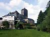
Kuks
[ Village or Town/City ]
[
gps
]
[
osm
]
, 290.00 m.n.m.
23.50 km
Heřmanice
[ Village or Town/City ]
[
gps
]
[
osm
]
, 280.00 m.n.m.
32.50 km
Jaroměř
[ Village or Town/City ]
[
gps
]
[
osm
]
, 265.00 m.n.m.
ukázat na mapě
INFORMATION:
http://www.podzvicinsko.cz
Type:
Tourist path KČT
LAST MODIFY:
Šormová Helena
(INFOSYSTEM s.r.o.) org. 2, 04.01.2022 v 02:16 hodin
[
Login
]
Copyright 1998-2025 ©
www.infoSystem.cz
,
součást prezentačního a rezervačního systému Doménová koule ®
Regiony a oblasti ČR
Tourist regions ČR
Turistické oblasti ČR
Search
Search centre
Rejstřík oblasti
Action databank
ZPRÁVY A AKTUALITY
Tiskové zprávy
Services for tourist
Information centres
Tourist guide services
Tlumočníci a překladatelé
Bankovní služby
Turistický produkt
Kalendář akcí oblasti
Akce pro děti
Kino, divadlo, výstavy
Folk activities and festivals
Tourist activities
Kalendář kongresů a konferencí
Kalendář veletrhů a výstav
Folklore and Traditions
Etnografický region
Etnografický subregion
Folk associations
Folk ensembles
Folk festivals
Folk traditions and customs
Folk craft and products
KLUB ČESKYCH TURISTŮ
Krajská oblast KČT
Odbor KČT
Turistické odznaky a známky
Regionální rozvoj
Regiony a sdružení
Investment opportunities
Průmyslové zóny
Properties for sale
Industrial production
Food production