KRKONOŠE SEVERNÍ MORAVA A SLEZSKO STŘEDNÍ MORAVA JIŽNÍ MORAVA VYSOČINA VÝCHODNÍ ČECHY ČESKÝ RÁJ ČESKÝ SEVER SEVEROZÁPADNÍ ČECHY ZÁPADOČESKÉ LÁZNĚ PLZEŇSKO ŠUMAVA JIŽNÍ ČECHY PRAHA OKOLÍ PRAHY PO RUSSKIPOLSKIFRANCAISDEUTSCHENGLISHČESKY
PODZVIČÍNSKO
  Road accessibility
Information centres
Towns and municipalities
Notable personality
Natural points of interest
Destinační management
 
Nature and its protection
  Natural points of interest
Caves and abysses
Vrcholy, hřebeny, sedla
Fauna a flora
Nature trails
 
Culture, entertainment, sport
  Culture and entertainment
Sport and relaxation
Zimní sporty
Katalog KUDY Z NUDY
Active holiday
 
Sights and Attractions
  Sights and architecture
Ecclesiastical monuments
Castles and chateaux
 
Tourism and leisure time
  Rural tourism
Hiking
Cycling tourism
Water tourism and sports
Wine tourism
 
Balneology
  Spas
Lázeňské domy a sanatoria
Medical cures
Natural medical sources
 
Congress Tourism
  Exhibitions and exhibition grounds
Congress centres
Exhibitions and promotion
 
Accommodation & dining
  Car-camping, camping site
Hotels, Boarding houses
Chaty a chalupy
Recreation areas
Further accommodation
Restaurants
Příjemné posezení
Gastronomic specialities
 
Království perníku

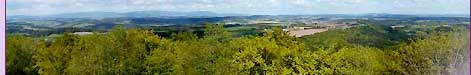
Basic informations [ Information service ]

Position of the Region Poodří
The village is situated along banks of the small river Luha that pours itself into Odra in cadaster of the village. The village was founded probably at the end of 12th century. At the present time Jeseník nad Odrou includes in sum five villages that were gradually connected (Jeseník n/O, Hrabětice, Polouvsí, Blahutovice, Hůrka). Through the village goes railway line Bohumín - Přerov which has stop here.
The highest place in the cadaster of the village: 384 m.n.m. - hill Hůrka
The lowest place in the cadaster of the village: 250 m.n.m. - junction of Odra and Luha

Basic geographical informations
Medium elevation above sea-level:264
Area in hectares: 2893,0537
Statistics of land resources
Agricultural land in
hectares:
2070,5331
Forest land in hectares:547,0583
Water areas in hectares:53,8594
Built-up areas in hecters: 42,7922
Other areas in hectares:178,8107
Intercurrent protected territories
Name of protected territory: Poodří
Category:Protected Landscape Area
Area in hectares intercurrent in territory of the village:444,415003
Intercurrent protective zone of spa and natural curative sources
Name of protective zone of spa and natural curative sources:Jeseník nad Odrou
Zone:5
Sort of protection:makeshift
Statute of protection: Makeshift protective zone of natural mineral waters
Division of agricultural land
Arable land in hectares:87,952
Gardens in hectares: 87,952
Fruit groves in hectares:0,9788
Meadows in hectares:161,8756
Pastures in hectares:32,828

LOCATION


LAST MODIFY: Ivana Náplavová org. 56, 09.12.2003 v 10:50 hodin
Copyright 1998-2024 © www.infoSystem.cz,
součást prezentačního a rezervačního systému Doménová koule ®
Regiony a oblasti ČR
  Tourist regions ČR
Turistické oblasti ČR
 
Search
  Search centre
Rejstřík oblasti
Action databank
 
ZPRÁVY A AKTUALITY
  Tiskové zprávy
 
Services for tourist
  Information centres
Tourist guide services
Tlumočníci a překladatelé
Bankovní služby
Turistický produkt
 
Kalendář akcí oblasti
  Akce pro děti
Kino, divadlo, výstavy
Folk activities and festivals
Tourist activities
Kalendář kongresů a konferencí
Kalendář veletrhů a výstav
 
Folklore and Traditions
  Etnografický region
Etnografický subregion
Folk associations
Folk ensembles
Folk festivals
Folk traditions and customs
Folk craft and products
 
KLUB ČESKYCH TURISTŮ
  Krajská oblast KČT
Odbor KČT
Turistické odznaky a známky
 
Regionální rozvoj
  Regiony a sdružení
Investment opportunities
Průmyslové zóny
Properties for sale
Industrial production
Food production